The famous hill station Pithoragarh is in Uttaranchal, which seems to be attracting a lot of tourists these days, because the state not only offers the tourists a chance to enjoy natural beauty but also a chance to try various adventure sports, such as white river rafting, hang-gliding and skiing. So whether you want to spend a holiday close to nature or have the time of your life. Come to Pithoragarh and make Hill resorts in India your travel partner, so you can choose the right holiday package to this beautiful hill resort.
Location Pithoragarh stands at a height of 1,851 meters in a valley, fondly called the 'Little Kashmir' in the northern state of Uttaranchal. The district covers an area of 8,856 square kilometers and it borders both Nepal and Tibet.
Places to Visit
While you are at a tour of Pithoragarh, you can check out a number of lakes around Pithoragarh. There are two of them which are quite famous, one of them being Jolingkong and the other one being Anchherital. While the former is at a height of 4,634 meters, the latter is situated at an altitude of 3,658 meters. The district is dotted all over with many old temples that you visit. There is a shrine at Purnagiri, which is only 20 kms from Tanakpur, and there is another Sikh shrine near Lohaghat called Ritha Sahib. According to a belief, Guru Nanak touched the bitter ritha and it turned sweet after his touch.A tour to the White Manu Temple is also a must if you are in Pithoragarh. It is dedicated to the Goddess, who on invocation brings rain thus good fortune to the mountains.
Excursion
If you are in Pithoragarh for a few days, you can travel to Baleshwar, which is 76km away on the Tankpur Road. There you can see the beautiful temples which were built by early Chand rajas in the 8th Century. About 77 kms from Pithoragarh is a Shaktipeeth, which was established by Adi Sankaracharya. About two kilometers away is Chamunda Devi temple.Around 14 kms from Gangolihat is Patal Bhubaneshwar, a temple, which is dedicated to Lord Shiva. Interestingly enough, one has to go through a tunnel to reach the temple.Around 62 kms from Pithoragarh is Lohaghat. About 2 kms from here is the Abbot Mount and Mayawati. At Mount Abbot, one can see a lot of Bungalows, which belong to the colonial era. This place also offers a great view of the Northern Hill Ranges. Mayawati is known for the headquarters of Adwait Ashram. At a distance of 7km from Pithoragarh is Chandak. It is at a height of 1,830 meters and offers a breathtaking view of the Pithoragarh valley. 20 kms from Tanakpur is Punyagiri, which has the Punyagiri temple, which is devoted to Maa Punyagiri.
 Mayawati Ashram
22 kms. from Champawat and 9 kms. from Lohaghat, this ashram is situated at an altitude of 1940 mts. Mayawati shot into prominence after the Advaita Ashram was established here. The ashram attracts spiritualists from India and abroad.
Abbot Mount
11 kms., Remarkable for scenic beauty Abbot Mount is situated 8 kms. from Lohaghat. The place is famous for peaceful secluded holidays .
Devidhura
45 kms from Lohaghat Devidhura is famous for its Varashi temple, where the traditional Bagwal (organised stone throwing between two grops) is held once every year on Raksha Bandhan.
Vanasur - Ka - Kila
This fort is situated at an elevation of 1859 mts., 7 kms. from Lohaghat and 20 kms. from Champawat. (Lohaghat to Karnakarayat is 6 kms. by bus and Karnakarayat to Vanasur-ka-Kila 1 km. by foot .
Visiting Pithoragarh
There are frequent buses to Pithoragarh from Almora, Nanital and Delhi, so getting to Pithoragarh by road is no problem.The closest railhead is at Tanakpur and the closest airport is at Patnanagar, which is 249kms from Pithoragarh.
Location Pithoragarh stands at a height of 1,851 meters in a valley, fondly called the 'Little Kashmir' in the northern state of Uttaranchal. The district covers an area of 8,856 square kilometers and it borders both Nepal and Tibet.
Places to Visit
While you are at a tour of Pithoragarh, you can check out a number of lakes around Pithoragarh. There are two of them which are quite famous, one of them being Jolingkong and the other one being Anchherital. While the former is at a height of 4,634 meters, the latter is situated at an altitude of 3,658 meters. The district is dotted all over with many old temples that you visit. There is a shrine at Purnagiri, which is only 20 kms from Tanakpur, and there is another Sikh shrine near Lohaghat called Ritha Sahib. According to a belief, Guru Nanak touched the bitter ritha and it turned sweet after his touch.A tour to the White Manu Temple is also a must if you are in Pithoragarh. It is dedicated to the Goddess, who on invocation brings rain thus good fortune to the mountains.
Excursion
If you are in Pithoragarh for a few days, you can travel to Baleshwar, which is 76km away on the Tankpur Road. There you can see the beautiful temples which were built by early Chand rajas in the 8th Century. About 77 kms from Pithoragarh is a Shaktipeeth, which was established by Adi Sankaracharya. About two kilometers away is Chamunda Devi temple.Around 14 kms from Gangolihat is Patal Bhubaneshwar, a temple, which is dedicated to Lord Shiva. Interestingly enough, one has to go through a tunnel to reach the temple.Around 62 kms from Pithoragarh is Lohaghat. About 2 kms from here is the Abbot Mount and Mayawati. At Mount Abbot, one can see a lot of Bungalows, which belong to the colonial era. This place also offers a great view of the Northern Hill Ranges. Mayawati is known for the headquarters of Adwait Ashram. At a distance of 7km from Pithoragarh is Chandak. It is at a height of 1,830 meters and offers a breathtaking view of the Pithoragarh valley. 20 kms from Tanakpur is Punyagiri, which has the Punyagiri temple, which is devoted to Maa Punyagiri.
Mayawati Ashram22 kms. from Champawat and 9 kms. from Lohaghat, this ashram is situated at an altitude of 1940 mts. Mayawati shot into prominence after the Advaita Ashram was established here. The ashram attracts spiritualists from India and abroad.
Abbot Mount
11 kms., Remarkable for scenic beauty Abbot Mount is situated 8 kms. from Lohaghat. The place is famous for peaceful secluded holidays .
Devidhura
45 kms from Lohaghat Devidhura is famous for its Varashi temple, where the traditional Bagwal (organised stone throwing between two grops) is held once every year on Raksha Bandhan.
Vanasur - Ka - Kila
This fort is situated at an elevation of 1859 mts., 7 kms. from Lohaghat and 20 kms. from Champawat. (Lohaghat to Karnakarayat is 6 kms. by bus and Karnakarayat to Vanasur-ka-Kila 1 km. by foot .
Visiting Pithoragarh
There are frequent buses to Pithoragarh from Almora, Nanital and Delhi, so getting to Pithoragarh by road is no problem.The closest railhead is at Tanakpur and the closest airport is at Patnanagar, which is 249kms from Pithoragarh.


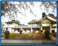
 Rich in history and beauty, Mussoorie has given birth to many institutions that are known virtually all over the country. Since 1959, the Lal Bahadur Shastri National Academy of Administration has been training and molding batch after batch of raw probationers into the country's finest bureaucrats, foreign service officers, and police officers. the Academy, situated at Charleville, continues to train officers for the Indian Administrative Service and the Indian Police Service. A fire broke out in the Academy some years ago and destroyed, among other buildings and papers, its precious library rated amongst the best in the country. While many of the books destroyed in the fire are difficult to replace, a new beginning has already been made by acquiring a fine collection of books.
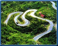 Mussoorie is a hill station which has pleasant climate around the year. It is a very cool place with greenery at its full bloom during September to November. The best seasons to visit Mussoorie is between April to June and again during September to November. When the plains of North India experience heat waves, Mussoorie provides a welcome break. September - November is spring time here. During this season Himalayas are clearly visible. It is better to avoid monsoons as the roads to Mussoorie are in bad shape. Same thing applies for the winter when roads are blocked due to snowfall